There's a new place on the grid that is so lovingly rendered and detailed, so flawlessly planned and scripted, and so very pleasing to the eye, that it is a credit not only to the people behind it but to virtual worlds, as well. 
David Rumsey has a Master of Fine Arts degree from Yale University and was a founding member of Yale Research Associates in the Arts. He has been an Associate Director of the American Society for Eastern Arts in San Francisco, a lecturer in art at the Yale Art School for several years, and a real estate developer. And then... around 1983, he began to collect maps. The fact that he has been living in the Bay Area comes as no surprise to me. As a book collector myself, I can tell you that many of the best rare books and ephemera stores in the world are found in that vicinity.
Today, and 150,000 historical maps later, David Rumsey Maps is one of the largest private map collections in the United States. Mostly, he has focused on cartography of the world of the 18th and 19th Centuries, but he has also gathered atlases, globes and maritime charts of Oceania, the America, Asia and Europe. In 1997, David turned to Cartography Associates to digitize his collection... and ten years later, he entered Second Life using an avatar by the name of Map Darwin (rez: 11/13/2007), and began seeking a way to translate his treasures on the 3D Internet. 
Meanwhile, Nathan Babcock (rez: 5/5/2006) is an associate creative director at Centric, an advertising agency based in Los Angeles with offices in New York, Shanghai, Tokyo and notably, Second Life, that has positioned itself as an Agency of Change. David Rumsey approached Centric to bring his collection to life, and now that relationship has changed the map of Second Life.

Nathan became the creative lead for David Rumsey Maps, and three months later a four sim wonder was completed that will open officially to the public on March 6, 2008 (teleport directly from here).
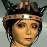
Nathan Babcock: The sculpty is the crown of the estate; it's not simply a hand sculpt. What you see is actual real life topography data brought inworld, so the map is true to scale. If your avatar is 3 inches tall, Yosemite is 1:1 scale. 
Here you see a framed illustration of the Grand Canyon in the distance.
Nathan Babcock: David Rumsey is a philanthropist and map collector. He wants to educate people on the history of maps and seeing what the world, or cities looked like through time. Topography is ever changing, and maps serve as historical snapshots.
Bettina Tizzy: Does he come in world ever?
Nathan Babcock: He does. He loves SL and will be giving a speech on the launch date. His maps are featured in Google Earth and Google Sky, and (he) does talks amongst the academic crowds all the time including Harvard.
When you visit, be sure to max out your draw distance (Preferences> graphics> Draw Distance> 512 - and don't forget to set it back to about 120 before you leave!). You will notice that the entire region (actually four sims) is covered in a map terrain of Yosemite Valley dating back to 1883. The terrain elevation is "real terrain" brought into Second Life by utilizing real topography height elevation models. In essence you are really flying through Yosemite.
"This is one of the earliest detailed surveys of Yosemite Valley in the Sierra Nevada Mountains of California. The map shows interesting cultural features in the valley, many of which no longer exist. The steep valley cliffs are shown with a map style of the 19th century called hachuring - closely spaced lines to indicate slope."
Fly to the center of the estate where you will find a circle platform and wait to rez everything completely.
Try clicking on "Height Map" to see the map of that quadrant represented as a flat map.
Then click "Fullbright," to set the bright effects, and alpha effects of each sim.

Due NW on the estate, you will see two colossal globes in the distance (thank you, huge prims). The first is the Globo Terrestre or World Globe dating back to 1790, by Giovanni Maria Cassini, that shows contemporary discoveries in the Pacific as well as the routes of three of Captain James Cook's voyages. 
Per the accompanying notecard: "Giovanni Maria Cassini was an important Italian engraver and painter based in Rome. In addition to producing globes and maps, he issued many engravings of landscapes and architectural views which were popular in his time. He was a member of the ancient Catholic religious order, Clerici Regulares de Somasca (C.R.S.), whose initials follow his name in the title of the Celestial Globe. Cassini was born in 1745 and died circa 1824." 
This photograph taken from inside the globe.
The globe furthest away, in a corner, is the Globo Celeste or Celestial Globe, dating back to 1792 and also created by Giovanni Maria Cassini.
Per the accompanying notecard: "The globe features a particularly decorative projection of the heavens with the constellations shown in their classical forms. The celestial globe is based on the astronomical observations of Flamsteed and Lacaille. Ptolemaic and later constellations are shown. Stars are illustrated at various sizes depending on their magnitude. The heavens are shown as they would be seen by an observer looking from the center of the earth."
This photograph taken from inside the globe, which also happens to be Nathan Babcock's favorite spot on the estate
Head back to the gift shop area (great freebies, by the way) and teleport up to see the topographical map of the city and streets of Old New York, dating back to 1836, by J.H. Coton.
Per the accompanying notecard: "Anson Stokes, an authority on the mapping of New York, said "This is one of the most beautiful nineteenth century plans or maps of Manhattan Island, and is full of interesting information. It is perhaps the last example of really artistic map-making, as applied to Manhattan Island." Central Park did not exist when this map was made, and most of Manhattan Island north of 42nd Street is shown as streams, woods, hills, fields, and farms."
Come back down and discover and claim your spot on the map of the world that enables a push-pin annotation of where you live along with a short blurb about it.
All photographs taken in AM Radio's Nostalgia Windlight Preset. Many thanks to our very own Amalthea Blanc for pointing me to this. :D
skip to main |
skip to sidebar


NPIRL founder - Madly, wildly embracing the impossible made possible in Virtual Worlds.
"I need a new clockwork brain!... Indeed, maybe two?"


A great place to rez your art and have it critiqued by art critics.


Not Possible IRL by Bettina Tizzy is licensed under a Creative Commons Attribution-Noncommercial-No Derivative Works 3.0 Unported License.

Join us in our quest to discover the best of Virtual Worlds
Experience - first-hand - the creations, ideas and innovations that are pushing the boundaries of what is real. No, we're not in Kansas anymore! Virtual worlds are where all the disciplines of art and technology combine to make for the most compelling and exciting adventure imaginable.
Blogger Bettina Tizzy
NPIRL founder - Madly, wildly embracing the impossible made possible in Virtual Worlds.
Blogger Alpha Auer
"I need a new clockwork brain!... Indeed, maybe two?"
Show me, I'll show you...
A central goal for us is to collect and distill what's really happening out there and pare down your options to the essence of what's cool, trendsetting and even groundbreaking, always within the context of Not Possible IRL. This is not intended as a calendar of events and our selections are, by necessity, subjective and opinionated. To learn more about the criteria for what is NPIRL, click here.
If you'd like to share a landmark, notecard or hot tip of any nature with us, kindly share it with us in-world. We try to always credit the finder, too.
If you'd like to share a landmark, notecard or hot tip of any nature with us, kindly share it with us in-world. We try to always credit the finder, too.
A great place to rez your art and have it critiqued by art critics.
Subscribe

"Not Possible IRL" members
- 3star Tyne
- Adam Ramona
- Aenea Nori
- Aeron Copeland
- Akasha Wachmann
- Aloah Oh
- Alpha Auer
- AM Radio
- Amalthea Blanc
- Amberly Kinsella
- Aminom Marvin
- Andrek Lowell
- AngryBeth Shortbread
- arabesque Choche
- Art Laxness
- artoo Magneto
- Avi Arrow
- Babbs Ballyhoo
- Barney Boomslang
- Beezle Warburton
- Ben Duranske
- Bettina Tizzy
- Beyers Sellers
- Bjorlyn Loon
- blotto Epsilon
- Blue Linden
- Bryn Oh
- Cheen Pitney
- Chenin Anabuki
- Chi5 Shenzhou
- Chimera Cosmos
- China Tracy
- CJ Carnot
- Comet Morigi
- Corporate Jay
- Crap Mariner
- Crash Prefect
- Cube Republic
- Cubist Scarborough
- Cutea Benelli
- Damanios Thetan
- DanCoyote Antonelli
- Darek Deluca
- Darkle Sands
- Daruma Picnic
- DB Bailey
- Desdemona Enfield
- Dirk Duettmann
- Dirk Talamasca
- Dizzy Banjo
- Domenico Quaranta
- Douglas Story
- DrenBoy Opus
- Dusan Writer
- Earth Primbee
- Easy Babcock
- Edgware Marker
- Edo Autopoiesis
- Eladon Galsworthy
- elros Tuominen
- Eshi Otawara has left the grid
- Evo Szuyuan
- Fau Ferdinand
- Flea Bussy
- Foolish Frost
- Four Yip
- Frank Koolhaas
- Gary Hazlitt
- Gattina Dumpling
- Gazira Babeli
- Georg Janick
- Gioacchino Laryukov
- Glyph Graves
- Gore Suntzu
- Gumnosophistai Nurmi
- Gwen Carillon
- Hamlet Au
- Hotspur Otoole
- Ian Pahute
- Iris Ophelia
- Jay Newt
- JenzZa Misfit
- Jessica Qin
- Jolly Jedburgh
- Jopsy Pendragon
- Julia Hathor
- juliet Heberle
- Juria Yoshikawa
- Jurin Juran
- Kazuhiro Aridian
- Kew Kew
- Keystone Bouchard
- Kid Kuhn
- KK Jewell
- Komuso Tokugawa
- Kriss Lehmann
- Lainy Voom
- Larry Pixel
- Lauren Weyland
- Lex Neva
- Light Waves has left the grid
- LittleToe Bartlett
- Lumiere Noir
- Lyric Lundquist
- Madcow Cosmos
- Man Michinaga
- Masami Kuramoto
- Max Newbold
- Meat Carver
- Mencius Watts
- Mescaline Tammas
- Misprint Thursday
- Molotov Alva
- MosMax Hax
- nand Nerd
- Nathan Babcock
- Naxos Loon
- Naydee McGettigan
- Nebulosus Severine
- Nectere Niven
- nonnatus Korhonen
- Olza Koenkamp
- Ordinal Malaprop
- Orhalla Zander
- Osprey Therian
- Pandora Wrigglesworth
- Patch Thibaud
- Patio Plasma
- Pavig Lok
- Penumbra Carter
- Ponk Bing
- Pooky Amsterdam
- Qarl Fizz
- RacerX Gullwing
- Random Calliope
- RightasRain Rimbaud
- Robbie Dingo
- Rubaiyat Shatner
- Sabine Stonebender
- Sasun Steinbeck
- Scope Cleaver
- Seifert Surface
- Selavy Oh
- Shava Suntzu
- Skills Hak
- soror Nishi
- Spiral Walcher
- Stella Costello
- Stephen Venkman
- Strawberry Holiday
- Suzanne Graves
- Tateru Nino
- Tayzia Abattoir
- TeeCee Towradgi
- Tezcatlipoca Bisiani
- Thinkerer Melville
- Thomtrance Otoole
- Thoth Jantzen
- Toady Nakamura
- Tom Bukowski
- Tooter Claxton has left the grid
- TracyLynne Carpenter
- Tryptofaa Sands
- Tuna Oddfellow
- Ty Gould
- Vlad Bjornson
- Wellington Bahram
- Werner Kurosawa
- Wizard Gynoid
- Yoa Ogee
- Yohann Emoto
- Yuki Aabye
- Zee Pixel
Popular blog posts
- Land Art in Second Life - A historical perspective and an introduction to Comet Morigi
- On artists and their patrons
- Will Your Work Day: Don't let your virtual creations die with you
- What every Second Life newbie should know - 10 secret tips
- Proper attribution of photos taken in virtual worlds
- Dear Bleeding Edge Corporations (that goes for you, too, Mr. Anderson)...
- Is Second Life the theatre of the absurd?
- Brooklyn is Watching (us)
- The Garden of NPIRL Delights
- The King is dead. Long live the King! Starax Statosky is gone, but Light Waves carries on
- Get your *own* grid! Thomtrance O’toole provides step-by-step instructions for OpenSim + binary executable
- David Rumseys Maps: Nathan Babcock's interactive sculpties bring cartography to life
- Second Life's huge prim problem - what we could not say...
- This is what Second Life should be like (and sometimes is)
- Flea Bussy’s empire: Grendel’s Children, one wacky avatar at a time…
- Looking to Real Life for NPIRL inspiration: Warning! Real Life peeps... you might be on my hit list
- MUST see by all builders
Blogs and Sites We Like
- Adam Ramona's website
- Aenea Nori's Second Life
- Alpha Auer
- Aminom Marvin
- AngryBeth Shortbread's Collective
- arcspace
- Ars Virtua
- Art Laxness (aka Will Segerman)
- Arthole
- artoo anyMotion's anymotion
- Avaria - The World of Grendel
- Avatar Orchestra
- Barney Boomslang
- Benjamin Duranske's "Virtually Blind"
- Beyers Sellers' Metanomics
- Boing Boing
- Brooklyn is Watching
- Bryn Oh
- Cheen Pitney's blog
- Chenin Anabuki - Avatrian
- Chimera Cosmos
- China Tracy's blog
- Chouchou - juliet Heberle and arabesque Choche
- Chromotive
- Comet Morigi
- Crap Mariner
- DanCoyote Antonelli's website
- Dark Roasted Blend
- DB Bailey's website
- Dizzy Banjo's website
- Domenico Quaranta's "Spawn of the Surreal"
- DrenBoy Opus - Opus Labs
- Dusan Writer
- eightbar
- elros Tuominen's blog
- Eshi Otawara
- Evo Szuyuan's Evolutie website
- Flea Bussy's "Grendels Children"
- Gary Hazlitt's website
- Gazira Babeli's website
- Gore Suntzu's Prim Abuser blog
- Gwen Carillon Designs
- Gwyneth Llewelyn
- Hibernia on the Skids
- Ian Pahute's website
- In a virtual sort of way
- Iris Ophelia's blog "Ophelia Drowns"
- Jopsy Pendragon's website
- Jurin Juran's blog
- Keystone Bouchard
- Kippie Friedkin's Grid Life
- Komuso Blues at sonicviz
- Kriss Lehmann's Straylight
- LanguageLab.com
- Lash Xevious' Tamed Frustration
- Lauren Live
- Lex Neva's blog
- Luna Zolnir
- Lyric Lundquist's Flickr stream
- Madcow's Madhouse of Building
- Massively
- Masterful Escape
- Memespelunk
- Mescaline Tammas' Flickr stream
- Molotov Alva
- MosMax Hax's website
- New Media Consortium in Second Life
- New World Notes
- nonnatus Korhonen's Miscellanea
- Olza Koenkamp's website
- Ordinal Malaprop's website
- Osprey Therian's Atomic Raygun
- Patch Thibaud
- Pavig Lok's blog
- Pooky Amsterdam's Pooky Media
- Qarl Fizz's qLab
- Random Calliope
- Reuters in Second Life
- Rezzable Productions
- Rhizome
- Robbie Dingo's Digital Double
- Sabine Stonebender's blog
- Sasun Steinbeck's list of art galleries
- Scope Cleaver
- Second Front
- Second Life Art News
- Seifert Surface's art
- Selavy Oh
- Skills Hak - Insilico
- smARThistory.us
- soror Nishi
- Spiral Walcher's website
- Stella Costello
- Stephen Venkman photography
- Strawberry Holiday
- Tateru Nino's Dwell On It
- TechCrunch
- Terra Nova
- Tezcatlipoca Bisiani (aka Andrew Sempere)
- The Clockwork Quartet - A steampunk band
- The Exploratorium in Second Life
- The Odyssey Project
- thomtrance Otoole
- Tooter Claxton
- Torley!
- Tryptofaa Sands' Tornado
- Tuna Oddfellow's website
- Virtual Art Initiative
- Vlad Bjornson's Shiny Life website
- Wizard Gynoid
- Yuki Aabye's Root of Euphoric Zone
- Zee Pixel's website
The NPIRL Recruitment Initiative - Come join us in virtual worlds:
Blog Archive
-
▼
2008
(446)
-
▼
February
(37)
- Fibreculture Journal critiques DanCoyote Antonelli...
- Great finds: Don't mess with the drill bit robot
- Catastrophe! - Space junk falls from the sky and w...
- Syncretia - A fictional world in subtle hues that ...
- Tuna's trippy textures
- Get de-noobed via one easy volume
- Contemplating virtual worlds: Dusan Writer nails it
- More Chouchou - Making music from somewhere far, f...
- Haute on the grid... Being dOts
- Navigating impossible objects via Echochrome
- Space Colony Necronom - A dark role-playing extrav...
- Chouchou "Islamey" - a club (and a video) that def...
- TracyLynne Carpenter's whimsical steampunk world
- "Shattered Sword" by Cheen Pitney
- Flea Bussy - Makin' stuff for the love of orks 'n ...
- Jaymin Carthage's fast-propagating "Branch" - Scri...
- Oyster Bay Sculpture Garden to shutter its doors
- Creators of 99rooms: Virtual worlds await you
- Ashanti LeShelle's photography articulates her dre...
- Heartstruck by LOVE... for sculpties
- Great news for Machinima makers: Lip sync in Secon...
- Second Lifers' love of wheat translates to *four* ...
- Playing with tornadoes... courtesy of Tryptofaa Sands
- The one, the only, Sabine Stonebender: Flickr grou...
- Thierry Mugler's sim hits a cool groove, but the c...
- David Rumsey's Maps: Nathan Babcock's interactive ...
- UNKLE - Eye for an Eye: ... wow
- Time Out!
- Mono highlight: Size limit for scripts up'ed to 64K
- Not Possible ISL? :P
- Cheen Pitney's "Sax Man"
- Dear Robert & Shana ParkeHarrison: Virtual worlds ...
- A color trend index and tool box: COLOURlovers
- Cheen Pitney's "Icarus"
- Rezzable Productions: The slippery slope of turni...
- A fair agreement between artists and contractors
- Believe it or Not: Drama Libre - The club that's b...
-
▼
February
(37)
NPIRL bloggers
Not Possible IRL by Bettina Tizzy is licensed under a Creative Commons Attribution-Noncommercial-No Derivative Works 3.0 Unported License.
A Glossary of Terms and Abbreviations Commonly Used in this Blog
- Cam - The act of zooming and panning one's viewer (camera)
- FLART - Flat art in a 3D world (more often than not, imported Real Life paintings and still photography)
- HUD (Heads-Up Display) - A visual display of preset options as part of the user interface (UI)
- In-world - Being inside or "online" in a virtual world
- IRL - In real life
- Landmark (LM) - An "address" and shortcut that enables a Second Life® resident to teleport to another place
- Linden - An employee of Linden Lab™, the company that owns Second Life®
- Linden Lab (LL) - The company that owns Second Life®
- Linden or $L - Currency in Second Life®
- Mega prim - A very large and useful prim that is not endorsed by Linden Lab, and not scaleable
- NPIRL - Not possible in real life
- NPISL - Not possible in Second Life®
- PIRL - Possible in real life
- Prim or Primitive - A 3D object that is manipulated and used as a basic building and creation material
- Rez - The action of creation in a virtual world; also the birthdate of an avatar/account
- Sim - A simulator and virtual region hosted by a single server CPU
- SLT (Second Life® Time) - Local time within Second Life®, which also happens to be Pacific Standard Time because Linden Lab is located in San Francisco, CA
- TP or Teleport - Moving from one location to another in a virtual world
- Windlight - Sky, water and atmospheric lighting effects in Second Life®
Weekly events worth attending
Labels
- "body parts" (2)
- "Not Possible IRL" (1)
- "Ordinal Malaprop (1)
- [DAM]Berlin (2)
- 10 tips (1)
- 109 Prims Circus (2)
- 17 Unsung Songs (1)
- 1920's Berlin Project (1)
- 2007 (17)
- 2008 (7)
- 2009 (1)
- 2D (6)
- 2D web (1)
- 3-axis accelerometer (1)
- 3D (16)
- 3D graphics (1)
- 3D Internet (3)
- 3D mesh (1)
- 3D mesh objects (2)
- 3D modeling (1)
- 3D printing (2)
- 3D Soup (1)
- 3Dconnexion (1)
- 3DMax (1)
- 3dsMax (2)
- 3FX (1)
- 3star Tyne (6)
- 4D (1)
- 713 Ayres (1)
- 7ommy Gunes (1)
- 99rooms (1)
- 99rooms.com (1)
- A Clockwork Orange (1)
- A Midsummer Night's Dream (1)
- abstract (4)
- Abstracting Craft (1)
- abstraction (1)
- abuse reports (1)
- academic (1)
- accelerometer (1)
- accessories (2)
- account (1)
- Act Up Theatre Company (1)
- acting (1)
- actors (1)
- ad farms (1)
- Ada Lovelace Day (1)
- Adam Frisby (1)
- Adam Nash (5)
- Adam Ramona (8)
- Adam Reuters (1)
- Adam Zaius (1)
- adobe (1)
- Adult (3)
- advertising (1)
- advice (1)
- Aenea Nori (1)
- afk (1)
- afterilfe (1)
- AFTRS (1)
- Agharta (1)
- agreement (1)
- ahkenatan Grommet (1)
- Ahmad Hosho (1)
- Aho (1)
- Aho Museum (2)
- AI (1)
- air kraken (1)
- aircraft (2)
- airship (1)
- Aiyas Aya (1)
- Aja Sinister (1)
- Akasha Wachmann (4)
- Akeyo (1)
- Akiyoshi Kitaoka (1)
- Akolyto Perfferle (1)
- Al Jazeera (1)
- Al Supercharge (1)
- al-zahra (1)
- Albert Duerer (1)
- alchemy (1)
- Aldomanutio Abruzzo (4)
- Alex Raymond (1)
- Alexandar Gallery (1)
- Alexandar Vargas (2)
- Alexander Beach (1)
- Alexander Vargas (1)
- Alexi Ayers (1)
- Aley Arai (4)
- algorithm (2)
- Aliasi Stonebender (1)
- Alice in Wonderland (2)
- Alien Isles (1)
- aliens (2)
- Allie Zigulis (1)
- Almacan (1)
- Alpha Auer (18)
- Alpha Tribe (1)
- altars (3)
- AlterEgoTrip Svenska (1)
- alternative (2)
- alternative-interface (1)
- alternatives (1)
- alts (4)
- AM Radio (30)
- Amalthea Blanc (8)
- amateur versus pro (1)
- Amber08 Festival (1)
- Amberly Kinsella (1)
- ambient music (2)
- ambient occlusion (1)
- American Cancer Society (5)
- Amerie Spitteler (1)
- Aminom Marvin (1)
- amphibian (2)
- amusement park (1)
- Amy Freelunch (2)
- Amy Wilson (2)
- Anakin Gallacher (2)
- analysis (1)
- Anatomia (1)
- anatomical drawings (1)
- anatomy (1)
- Ancient Egyptian (1)
- Andre Breton (1)
- Andrek Lowell (8)
- Andrew Burrell (3)
- Andrew Huang (1)
- Andrew Linden (2)
- Andrew Sempere (1)
- Andrew Wyeth (1)
- Androclese Antonelli (1)
- Andromeda (1)
- Andromega (1)
- Andy Warhol Foundation (1)
- AngelGate (1)
- angels (1)
- AngryBeth Shortbread (5)
- Anhinga Chaika (1)
- Anibal Shui (1)
- animation (5)
- animations (3)
- animatronics (1)
- anime (3)
- Anita Fontaine (1)
- Annabelle Fanshaw (1)
- Annabeth Robinson (1)
- Annie Obscure (1)
- anniversary (1)
- answers (1)
- Antony Garrett Lisi (1)
- anyMotion (3)
- aoimizuno Meili (4)
- AOM (1)
- ape (1)
- apes Later (1)
- apparel (1)
- apples (1)
- applications (1)
- arabesque Choche (11)
- Arahan Claveau (6)
- Arcadia Asylum (2)
- Arcanus Projects (1)
- archetypes (2)
- Archimboldo (1)
- architect (1)
- architecture (28)
- architecure (1)
- arcspace (5)
- ariel Brearly (1)
- armament (1)
- ArminasX Saiman (1)
- Ars Electronica (1)
- Ars Simulacra (1)
- Ars Virtua (3)
- art (156)
- Art Box (1)
- art critique (1)
- art deco (2)
- Art Laxness (5)
- Art:21 (1)
- Arthole (2)
- Arthole Radio (1)
- artificial intelligence (3)
- artificial life (1)
- artist (4)
- Artistic License (1)
- artists (4)
- artoo Magneto (7)
- Arts (3)
- Arts and Crafts Movement (1)
- Ash Soyinka (1)
- ashanti LeShelle (4)
- Ashen Coalcliff (1)
- Ask.com (1)
- asset management (1)
- asset servers (1)
- astrobiology (1)
- astrology (1)
- Atelier Ten Architects (1)
- atmospheric (1)
- Atom Burma (1)
- attribution (1)
- Auction (1)
- audience (1)
- audio (1)
- augmented (2)
- AuraKyo Insoo (1)
- Aurora Room (1)
- Austin (1)
- Australia (1)
- Australia Council for the Arts (2)
- Australian Centre for Photography (1)
- Australian Laboratory for Advanced Media Production (1)
- author (1)
- Autodesk Maya (1)
- automatic playing piano (1)
- autopoiesis (1)
- Autumn Hykova (1)
- Avant Scofield (1)
- Avaria (2)
- avatar (73)
- avatar art (1)
- avatar attachment (6)
- Avatar Blanks Factory (1)
- Avatar Factory (1)
- Avatar Hangout (1)
- Avatar Orchestra Metaverse (1)
- Avatar Reality (3)
- Avatar Rendering Cost (1)
- Avatarium (1)
- avatars (22)
- Avatrait (1)
- Avatrian (2)
- Avi Arrow (4)
- AVICOM (1)
- avitanimation (1)
- AVZ Cyberpunk Fashion (3)
- award (2)
- AWOL (1)
- Axelia Meili (1)
- AzA Zymurgy (1)
- B and W (1)
- BabelSwarm (1)
- baby (1)
- balance (3)
- Balistik Builders (1)
- bamboo (1)
- bandage (1)
- Banksy (1)
- Barack Obama (1)
- Barbara Binder (1)
- Bare Rose Tokyo (2)
- Bark Aabye (1)
- Barney Boomslang (2)
- Baron Grayson (7)
- Basilica (1)
- BastChild Lotus (1)
- Bathsheba Grossman (1)
- bats (1)
- battle (1)
- Bauhaus (2)
- BBC (1)
- BCI (1)
- Beatrix Newt (2)
- beauty (1)
- bebop (1)
- Bebop Vox (1)
- Beckenbauer Productions (1)
- bees (1)
- Believe it or Not (1)
- Beliria Lumley (1)
- Ben Lindquist (1)
- Beneath the Tree that Died (1)
- benefactors (1)
- benefiting real life (5)
- Bentham Forest (1)
- Berardo Carboni (1)
- Berlin (1)
- best (1)
- Best of Brooklyn is Watching Year 1 Festival (1)
- beta (3)
- Beth Harris (1)
- Betlog Hax (1)
- Bettina Tizzy (9)
- Beyers Sellers (4)
- big game hunting (1)
- Big Psomm (1)
- BigPond (1)
- Bill Watterston (1)
- billing bug (1)
- binaries (1)
- binary executable (1)
- Bingo Onomatopoeia (1)
- bio-art (1)
- Bioephemera (1)
- biology (3)
- biomechanics (1)
- bionics (1)
- bird (2)
- birds (2)
- Birmingham UK (1)
- birth (1)
- birthday (3)
- Bitter Thorns (2)
- Bjorlyn Loon (4)
- Black Swan (6)
- Blackthorn Hare (2)
- Blackwater Gallery (2)
- blender (5)
- blog (2)
- blogging (4)
- blood (1)
- blotto Epsilon (4)
- Blue Bay Beach Club (1)
- Blue Galaxy (1)
- Blue Mars (6)
- Blue Tsuki (1)
- Blume Boucher (1)
- body (2)
- body/avatar (1)
- bodybuilder (1)
- Bogon Flux (3)
- book (1)
- book signing (1)
- Boot Camp (1)
- Borromean rings (1)
- Bosch (1)
- BOSL Theatre (1)
- bot (1)
- bot farm (1)
- botanical (1)
- Botany Black (1)
- bots (2)
- Boudoir Rouge (2)
- Bounce (1)
- Bradley Litwin (1)
- brain (1)
- brain jar (1)
- branch (2)
- Branco Merlin (1)
- branding (2)
- brass (1)
- Brave New World (1)
- breather space (2)
- Brian Eno (1)
- Brian Sutton Smith (1)
- Bridie Linden (1)
- Bright Relics (1)
- Brigit Lichtenegger (2)
- Brigitte Kungler (1)
- British Council (1)
- Broadmead (1)
- Broet (1)
- Brooklyn is Watching (13)
- Brothers Grimm (1)
- Brown University (1)
- Browser (2)
- Bruce Branit (1)
- Bryn Oh (17)
- Buckminster Fuller (1)
- Buffy Beale (1)
- bug (1)
- bug reports (1)
- build festival (1)
- builder (1)
- BuilderBot (1)
- builders (1)
- building (11)
- building tools (1)
- builds (1)
- bulding (1)
- burial (1)
- Burning Life (24)
- Burning Man (4)
- burnout (2)
- business (3)
- Bussard Ramjet (1)
- butterfly hunt (1)
- C:A:R:P: musical (1)
- cage (1)
- Cai Guo-Qiang (1)
- cake (1)
- Caledon (3)
- Calliope (1)
- Callipygian Christensen (1)
- Calvin and Hobbes (1)
- camera movements (1)
- camming (1)
- cancer research (2)
- candy corn (1)
- Cao Fei (2)
- CARA (1)
- carnival (1)
- Carnivale Amusement Park (1)
- Caroline McCaw (1)
- Carrah Rossini (1)
- carriage (1)
- cars (1)
- cartoon (1)
- Casa del Shai (1)
- Cascade Rezzable (1)
- cat (1)
- caterpillar (1)
- Catfart Greyson (1)
- Catnip (1)
- cave (1)
- Cel Edelman (1)
- cellular automata (1)
- CensoredMy Lunt (1)
- censorship (4)
- Central Grid (1)
- CEO (1)
- cerdwin flanagan (1)
- ceremony (1)
- Cetus Institute (1)
- CGI (1)
- chairs (1)
- Chakryn (1)
- Chakryn Forest (4)
- challenge (2)
- Chambre du Chocolat (2)
- Chameleon (1)
- Chance Abattoir (2)
- characters (1)
- charity (1)
- Charlene Trudeau (1)
- Charles C. Ebbets (1)
- Charles Darwin (1)
- Charlie Omega (1)
- Charlie Parker (1)
- Charon (1)
- Chasm (2)
- Cheen Pitney (7)
- Chenin Anabuki (2)
- Chi5 Shenzhou (1)
- Chiaki Jie (1)
- Chiaroscuro (1)
- Chief Technology Officer (1)
- Chime Desoto (2)
- Chimera Cosmos (1)
- chimp (2)
- China Tracy (2)
- Chouchou (12)
- Chouchou "Islamey" (3)
- Chris Anderson (2)
- Chris Harding (1)
- Chris Marker (3)
- Christian Renaud (1)
- Christmas (4)
- Christopher Dodds (1)
- Cinderella (1)
- cinema (2)
- Cinemax (1)
- Citrinitas (1)
- city planning (1)
- CJoke Oh (2)
- Clarabelle Cazalet (1)
- clocks (1)
- Clockwork Quarter (1)
- clockworks (1)
- closed (1)
- clothes (2)
- Cloud Chateau (1)
- Cloud Insoo (1)
- clouds (1)
- club (4)
- club NEVERDIE (1)
- clues (1)
- CNN (1)
- Cocoloco (1)
- code (3)
- code performance (2)
- Code Red (1)
- CodeBastard Redgrave (2)
- coding (4)
- CoLab (1)
- ColeMarie Soleil (2)
- Colgate-Palmolive (1)
- Colin Fizgig (3)
- collaboration (2)
- collaborative design (1)
- Collabricate (1)
- collage (2)
- Collateral Damage (2)
- colonies (1)
- colony (1)
- colors (1)
- colossal (1)
- COLOURlovers (1)
- colours (1)
- COM (1)
- COM Collection 2008 (1)
- COM Fun Club (1)
- coma (1)
- Come Fly with Me (1)
- Comet Morigi (2)
- comic (1)
- commercial (1)
- commissioned works (1)
- communications (1)
- community (5)
- community relations (2)
- competition (2)
- complexification (1)
- computational metaphysics (1)
- computer graphics (1)
- computers (1)
- conception (1)
- conceptual art (2)
- concert (1)
- Condos in Heaven (1)
- Congress (2)
- contemplative (1)
- contemporary (1)
- content (3)
- content creation (49)
- content creator (3)
- content creators (2)
- contest (3)
- contour (1)
- contract (1)
- contractors (1)
- controlled camera (2)
- controversial (1)
- cool stuff (1)
- copybotting (2)
- copyright (8)
- Corbett Howard (1)
- Corporate Jay (2)
- corporate presence (1)
- corporations (2)
- Corro Moseley (2)
- Cortech (1)
- Cory Ondrejka (1)
- Costa-Hoffman-Meeks Surface (1)
- costume (1)
- Count Avatar (1)
- Count Mercier (1)
- CounterpART Gallery (1)
- couture (2)
- cows (1)
- CoyoteAngel Dimsum (1)
- crackers (1)
- crackle (1)
- Cradle and Trap (1)
- craftsmanship (1)
- Crap Mariner (5)
- CrazyTalk (1)
- Creamshop (1)
- Creative Commons (3)
- Creative Machinery (1)
- creative platform (1)
- creative writing (2)
- creativity (6)
- creatures (2)
- credits (1)
- Crescent Moon Museum (7)
- crime scene (1)
- critique (2)
- crooked house (1)
- crop circles (1)
- CryEngine2 (4)
- Crytek (2)
- CSI:NY (1)
- CSUS (1)
- Cube Inada (3)
- Cube Republic (2)
- Cubey Terra (1)
- Cubist Scarborough (1)
- culture (1)
- cupid (1)
- Curio Obscura (4)
- currency (1)
- customer service (1)
- cute (1)
- cutea Benelli (9)
- Cuwynne Deerhunter (5)
- cyberbunker (1)
- Cyberloom (1)
- cybernetic (1)
- cybernetics (1)
- cyberpunk (5)
- cyborg (2)
- Cyia Kanami (1)
- Cylindrian Rutabaga (1)
- Cypress Rosewood (1)
- D. DiFonzo (1)
- da Vinci (1)
- Daden (1)
- Daden Limited (1)
- Daegu (1)
- Daemon Nikitin (2)
- dai Lageos (1)
- Dallas Museum of Art (1)
- Dallas Virtual Worlds (1)
- Damanios Thetan (1)
- Damien Fate (1)
- Dammit Dawg (1)
- dance (2)
- dancing (1)
- DanCoyote Antonelli (15)
- Daniel Luchador (1)
- Darek Deluca (5)
- Dark Roasted Blend (1)
- Dark Victoria (1)
- Darkle Sands (1)
- darkness (1)
- Daruma Picnic (3)
- data visualization (2)
- database (1)
- Daughter of the Gears (1)
- David Burden (1)
- David Denton (1)
- David Kaskel (1)
- David Perry (1)
- David Rumsey (1)
- David Rumsey Maps (1)
- David Trautrimas (1)
- Day of the Dead (3)
- DB Bailey (6)
- DC Spensley (6)
- Deakin (1)
- death (3)
- Deep Sea Fluorescent Flower (1)
- deep space (1)
- DeepGrid (1)
- Dekka Raymaker (2)
- Del May (1)
- deletion (1)
- Delia Lake (1)
- delivery (1)
- demo (1)
- demolition (1)
- demonic (1)
- Dennis Moser (1)
- depth (1)
- derivative (1)
- Desdemona Enfield (6)
- design (15)
- Designer Dingson (1)
- Desperado (1)
- Destany Laval (1)
- destructible buildings (1)
- Detman Entertainment (1)
- Deviant Art (1)
- Dia de los Muertos (1)
- Diane Gromala (1)
- digital (1)
- digital art (2)
- Dil Spitz (1)
- Dimitrio Lewis (1)
- Dingle Doigts (1)
- dinosaurs (1)
- Dirk Talamasca (4)
- Dirkthecow Writer (1)
- Dirty Lynx (1)
- Dirty McLean (1)
- disable camera constraints (1)
- disaster (1)
- disconnected (1)
- Disembodied Hand (1)
- distance learning (1)
- Dizzy Banjo (6)
- DNA (1)
- Dnali Anabuki (1)
- documentaries (1)
- documentarist (1)
- documentary (2)
- Doll Face (1)
- Dolphin Safe (1)
- dolphins (1)
- Domenico Quaranta (4)
- Domino Marama (1)
- Don Carrol (1)
- donhosho (1)
- donuts (1)
- doom (1)
- Doriru Robo (1)
- Double Negative (1)
- Doug Anderson (1)
- Douglas Gayeton (3)
- Douglas Story (16)
- downloadable (1)
- dozzydolly Biziou (1)
- Dr. Muglerstein (1)
- Dr. Ruth Ballard (1)
- Dr. Spock (1)
- Dr. Strangelove (1)
- dragon (2)
- Drama Libre (2)
- Dreams (3)
- Dreamscapes Gallery of Art (1)
- DrenBoy Opus (1)
- dress (2)
- Drifter Rhodes (1)
- Drill Robo (1)
- Droste effect (1)
- drum (1)
- Duchess of Loch Avie (1)
- Ducky (1)
- Dusan Writer (7)
- Dutch Docklands (1)
- DynaFleur (1)
- dynamic shadows (1)
- dynamic water (1)
- E8 (3)
- Eagles (1)
- early adopters (2)
- ears (1)
- Earth (1)
- Earth Art (1)
- Earth Island Institute (1)
- Earth Primbee (7)
- Earth Records (1)
- Easy Babcock (2)
- Echochrome (1)
- Eco-Friendly Community (1)
- ecology (1)
- economy (5)
- ecosystem (1)
- Ed Miracle (1)
- Edgware Marker (1)
- Edo Autopoiesis (1)
- Edo Paulus (1)
- education (3)
- Edvard Munch (1)
- Edward Gorey (2)
- Edward Hopper (1)
- Eero Saarinen (1)
- eko Merlin (2)
- Eladrienne Laval (1)
- elections (1)
- electric (1)
- electric hair (1)
- Electric Sheep Company (1)
- electronics (1)
- electrostatic (1)
- Elements in Design (1)
- Elevator Angels (1)
- elf (1)
- Elif Ayiter (10)
- Elizabeth Tinsley (1)
- Elizabethan (1)
- Eln Alter (2)
- Elros Tuominen (5)
- elven (1)
- Elzbiet Meili (1)
- email (2)
- embedded (1)
- Emerald Viewer (1)
- emergent (1)
- Emily Lelouch (1)
- engine (1)
- engineering (1)
- English (1)
- English language (1)
- Enniv Zarf (1)
- entertainment (1)
- environment (3)
- episodes (1)
- equilibrium (1)
- Ern Malley (1)
- Ernst Haeckel (1)
- Error (1)
- eruption (1)
- Eshi Otawara (17)
- estate (2)
- Esther DeCuir (1)
- Esther Shim (1)
- Eterna (1)
- Eternal Moonwalk (1)
- Ethereal Slate (1)
- Ethereal Teal (2)
- Eva Bellambi (1)
- events (3)
- Eves Rodenberger (1)
- evets Igaly (1)
- Evo Szuyuan (10)
- evolution (1)
- exaggerated (1)
- exhibit (2)
- ExhibitA (1)
- exhibition (1)
- Experimental Game Lab (1)
- experts (1)
- exploration (3)
- explosives (1)
- Extropia (2)
- eyeco Noel (1)
- eyelashes (1)
- eyes (2)
- fabioparis art gallery (2)
- FACT (1)
- factory (1)
- Fade Dana (1)
- faeries (1)
- Fairchang Isle (1)
- fairy tale (1)
- Faith (2)
- Faith Rosenberg (1)
- fantasy (3)
- Far East Recording (1)
- farewell (1)
- Farnsworth House (1)
- Farrar Straus and Giroux (1)
- fashion (29)
- fashion design (1)
- Fashion Institute of Technology (3)
- Fashion Research Institute (1)
- Fau Ferdinand (2)
- Feathers Boa (1)
- feature film (1)
- feel good (1)
- feline (3)
- Felix (1)
- Felix Wakmann (2)
- Felixx Shepherd (1)
- Felony Fabre (1)
- Feri Beckenbauer (1)
- Fernando Pessoa (1)
- festival (2)
- Festival della Creativita (1)
- Festival of Creativity (1)
- festivals (1)
- festive season (1)
- fetus (1)
- fibonacci sequence (1)
- Fibreculture Journal (1)
- FIC (1)
- fictitious (1)
- film (6)
- filtering (1)
- Filthy Fluno (1)
- Finny Yates (1)
- fireworks (1)
- First Look (2)
- fishook dress (2)
- Five Star Fall (1)
- FLART (1)
- Flash art (1)
- Flash Gordon (2)
- flashback (1)
- flat art (3)
- Flea Bussy (4)
- Fleur de Lys (1)
- Flickr (16)
- flight (3)
- floating (1)
- flora (1)
- Florence (1)
- Florence Babenco (1)
- florenze Kerensky (1)
- Flory Watanabe (1)
- Flower Tower (2)
- FlowerBall (3)
- flowers (4)
- flycam (1)
- flying (2)
- Foolish Frost (5)
- Force Sun to Midnight (1)
- forensic techniques (1)
- forest (3)
- forests (1)
- form follows function (1)
- Formes Nocturnes (1)
- Forseti Svarog (1)
- Fotoscope (1)
- four Yip (17)
- FOV monitor (1)
- fractal (1)
- fractals (1)
- Fragula (1)
- Franco Brambilla (1)
- Frank Biocca (1)
- Frank Koolhaas (2)
- Frank Sinatra (1)
- Frankie Rockett (1)
- Freak Show (1)
- Freakshow (1)
- freebies (14)
- freedom (2)
- Frequency Picnic (1)
- freres hueon (1)
- friend (1)
- friends list (1)
- frogs (1)
- Fry Art Museum (1)
- Full Immersion (1)
- fun (4)
- function of xyz (1)
- fundraiser (5)
- fundraising (1)
- Furia Freeloader (2)
- furniture (3)
- furries (1)
- furry (3)
- Future (2)
- FutureLab (1)
- Futuretopia (1)
- Fylkingen (1)
- gadget (1)
- Gala Charron (1)
- Galaxy Girl (1)
- gallery (2)
- game engine (1)
- games (1)
- gaming (1)
- Garden of NPIRL Delights (24)
- Garrett Lisi (2)
- Gary Hayes (5)
- Gary Hazlit (1)
- Gary Hazlitt (11)
- Gary Kohime (2)
- Gattina Dumpling (4)
- Gaynor Gritzi (1)
- Gaz of the Desert (1)
- Gazira Babeli (10)
- gazworks (1)
- Gemini Cybernetics (1)
- Gemini Viewer (1)
- Gene Replacement (1)
- genetics (1)
- Genome (1)
- geocoded map (1)
- geodesic dome (1)
- geometry (1)
- geotagged news (1)
- gestures (3)
- getting started (2)
- ghost (1)
- giant (2)
- giant prims (3)
- Giant Snail Races (2)
- Gideon Baws (1)
- Giff Constable (1)
- gift (2)
- gifting (1)
- gifts (1)
- GigaOM (2)
- Gina Glimmer (1)
- Gino McCallister (1)
- Gioacchino Laryukov (1)
- Giorno Brando (1)
- Giovanni Baglione (1)
- glass (1)
- Glico Co (1)
- glider (1)
- Global Attack (1)
- Global Kids (3)
- global warming (1)
- glow (4)
- Glyph Graves (6)
- GM Kurosawa (2)
- GMO (1)
- gnome (1)
- goblins (1)
- God (1)
- God and virtual God (1)
- GodArt (1)
- Godzilla (1)
- good manners (1)
- Goodwill Epoch (1)
- Google (4)
- Google Earth (1)
- Gore Suntzu (3)
- gorilla (1)
- Goroka (1)
- Goth (1)
- Grace Loudon (1)
- Grady Echegaray (1)
- Grafx Newbold (1)
- Graham Stanley (1)
- Grand Odalisque (1)
- Graphic Design (2)
- graphics (2)
- graphics design (1)
- graphs (1)
- gravity (1)
- Gray's Anatomy (1)
- GrayNoise (1)
- great content (1)
- greed (1)
- Green Phosphor (1)
- Greenies (3)
- Greenies Home Rezzable (5)
- Grendel's Children (4)
- Grenoble Universities (1)
- grey goo (1)
- Grim Bros. (3)
- Grimly Graves (1)
- ground textures (1)
- group (1)
- groups (1)
- growth (1)
- Guggenheim (3)
- guided tours (1)
- guidelines (1)
- Guillame (1)
- guitars (1)
- Gus Plisskin (1)
- GutterBlood Spoonhammer (1)
- Gwen Carillon (2)
- hair (5)
- Hair Fair (1)
- Hair Fair 2009 (1)
- Hairspray (2)
- Hall of Twisty Smears (1)
- Hall of Wonders (1)
- Halloween (13)
- Hambone Slash (1)
- Hamlet Au (9)
- Happy (2)
- Happy Clam Island (1)
- Happy Mood (1)
- Hardwarehacker Hoch (3)
- Harlan Ellison (1)
- HarperCollins (2)
- hat (1)
- Hat Mechanic (1)
- hats (1)
- haunted (1)
- Havok 4 (1)
- Havok4 (1)
- Havok4 physics engine (1)
- HBO (3)
- heaven (1)
- Heavenly love conquering earthly love (1)
- Heifer International (4)
- helix (1)
- hell (1)
- Hello Kitty (1)
- helmets (1)
- Henmations (1)
- Henry Segerman (5)
- HERD (1)
- heritage (1)
- Hern Worsley (4)
- Heterotroph (1)
- Hibernia on the Skids (1)
- Hide and Seek (1)
- Hidenori Watanave (1)
- hierarchy (1)
- Higashiosaka (1)
- Higbee Protagonist (1)
- Hip (1)
- hip-hop (1)
- HIPiHi (2)
- historic style (2)
- historical recreation (1)
- History (1)
- hit list (2)
- Hitomi Mokusei (1)
- Hobos (1)
- Hogwarts School (1)
- holidays (1)
- Hollow Forest (1)
- Holly Loll (1)
- home (1)
- homosexuality (1)
- Honey Fairweather (1)
- horns (1)
- Horseless Gown (1)
- Hotel California (1)
- Hotel Dare (3)
- Hotspur O'Toole (3)
- house (2)
- houses (1)
- HTML (1)
- html on a prim (1)
- HUD (3)
- huge (1)
- huge prims (10)
- human body (1)
- human rights (1)
- human-machine (1)
- hummingbird (1)
- humor (2)
- hunger (1)
- Huret and Sector Gallery (1)
- Husk (1)
- Hussein Chalayan (1)
- hybrid (2)
- hypercube (2)
- Hyperformalism (6)
- hyperreal (2)
- Hz (1)
- i.mirror (1)
- Ian Pahute (3)
- Ian Truelove (1)
- Ian Upton (3)
- IBM (3)
- Icarus (2)
- Ichibot Nishi (1)
- Ichiro Furse (1)
- ICOM (1)
- ideas (1)
- identity (1)
- idoru Ng (1)
- illustrations (1)
- image processing (1)
- imagery (1)
- images (1)
- imagination (5)
- immersion (4)
- Immersiva (3)
- immersive (13)
- Imogen Heap (1)
- impact (1)
- ImpIRL (3)
- Impossible IRL (25)
- impossible triangle (2)
- IMs (2)
- in-world (2)
- in-world notices (1)
- index (1)
- Industrial (2)
- ine Wave (1)
- influence (1)
- infomercial (1)
- infomercials (1)
- information (1)
- infovis (1)
- Inigo Dench (1)
- innovation (5)
- Innsmouth Island Airship Tower (1)
- Inquisitr (1)
- INRIA (1)
- insects (1)
- Insilico (2)
- inspiration (1)
- Inspire Beach (1)
- Inspire Beach n Chill Park (1)
- Inspire Space Park (1)
- installation (7)
- Institute for Digital Intermedia Arts (1)
- instrumentation (1)
- Intan Eksotics (1)
- integration (1)
- intellectual property (4)
- Intellectual Property Garden (1)
- Intelligence Revolution (1)
- interactive (6)
- interactive architecture (1)
- interactive art (6)
- Interdimensional Alien Flying Circus (1)
- interface (2)
- International Council of Museums (1)
- International Justice Center (2)
- International Space Station (1)
- Internet (1)
- Internet Radio (1)
- interview (1)
- intuitive (1)
- invention (1)
- inventory (1)
- inventory loss (2)
- IP (3)
- IP protection (3)
- Iris Ophelia (2)
- Iron Serpente (1)
- Ironclads (1)
- Islamey (2)
- islands (1)
- issue (1)
- Istanbul (1)
- iTunes (1)
- Ivory Tower (1)
- Ivory Tower of Prims (1)
- Ivy Falls Talent (1)
- Jack the Pelican Presents (5)
- Jackie Jetcity (1)
- Jake Detman (1)
- jam (1)
- James and the Giant Peach (1)
- James Cameron (1)
- Jamie Clementine (1)
- Jamma Newt (1)
- Japanese (2)
- Japanese biscuits (1)
- Jared Tarbell (1)
- Jaron Lanier (1)
- Jason de Caires Taylor (1)
- Jason Groves (1)
- JavaScript (1)
- Jay Newt (4)
- Jay Van Buren (4)
- Jaymin Carthage (2)
- jazz (1)
- jdome Project (1)
- Jean-Baptiste Lamarck (1)
- Jean-Michel Crettaz (1)
- Jedda Zenovka (1)
- Jeff Lipsky (1)
- Jeffrey Ventrella (1)
- Jenene Lemaire (1)
- Jennifer Hana (1)
- JenzZa Misfit (1)
- Jeremy Owen Turner (1)
- Jessica Qin (2)
- Jessica Williams (1)
- jetpack (2)
- jewelry (2)
- Jewish Home (1)
- Jigoku (1)
- Jigoku Landman (1)
- Jim Sink (3)
- Jimbo Perhaps (1)
- Jing (1)
- JIRA (3)
- Jo Heartsdale (1)
- Jo Yardley (1)
- Jo-Anne Green (2)
- Joga Kidd (1)
- JoHan Glenville (1)
- Johan Huizinga (1)
- Johannes Buenemann (1)
- John P. Crane (1)
- join (1)
- joke (1)
- Jolly Jedburgh (2)
- Jon Brouchard (2)
- Jon Brouchoud (3)
- Jon Himoff (1)
- Jon Rafman (1)
- Jopsy Pendragon (7)
- Jordan Giant (1)
- Joseph Campbell (1)
- Josh Sommers (2)
- Josina Burgess (1)
- journal (1)
- journalism (3)
- JovialProductions (1)
- joy (1)
- Juana Manuel (1)
- Juju Dollinger (1)
- Juko Tempel (2)
- Julia Hathor (1)
- Juliet Ceres (1)
- Juliet Heberle (12)
- June Dion (2)
- Jung (1)
- Junivers Stockholm (1)
- Juria Yoshikawa (14)
- Jurin Juran (12)
- Justen Jigsaw (1)
- justice (2)
- Justin Clemens (1)
- Ka Rasmuson (1)
- Kabbalah (1)
- KABUKI (1)
- KadeKlata Karson (1)
- Kaeli Candour (2)
- Kaelie Candour (1)
- kaleidoscope (1)
- Kalepa (1)
- karma (1)
- Katati Noel (1)
- KatatOnik Pidgeon (1)
- katy Polikarpov (1)
- Kay Fairey (1)
- Kazuhiko Nakamura (1)
- Kazuhiro Aridian (7)
- Kean Kelly (1)
- Keiko Morigi (1)
- Keio University (1)
- Keith Extraordinaire (1)
- Kennesaw State University (2)
- Kevlar Keen (1)
- Keystone Bouchard (9)
- Khamon Fate (1)
- Khamudy Mannonen (1)
- Kheph777 Enoch (1)
- Kid Kuhn (1)
- kids (1)
- Kim Anubis (1)
- Kim Köster (1)
- Kimberly Mirabeau (1)
- kinetic (12)
- Kinetic Works (2)
- Kings Rezzable (1)
- Kirk Nabob (1)
- Kirsten Kiser (1)
- KirstenLee Cinquetti (1)
- Kiss the Sky (1)
- Kisskiss Zemlja (1)
- kit (1)
- kite (1)
- kitsch (1)
- KK Jewell (3)
- Klabauterklaus Maximus (1)
- Klein Bottle (1)
- Koinup (7)
- kokiriko bushi (1)
- Komuso Tokugawa (5)
- Konica Minolta (1)
- Kool-Aid Man in Second Life (1)
- Korgi Lerwick (1)
- Kriss Lehmann (1)
- Krius Misfit (1)
- KU art (1)
- Kurou Soldier (1)
- L'Oreal (1)
- La Luz de Jesus (1)
- La Machine (1)
- La Reve (1)
- laboratory (1)
- Lacey Mertel (1)
- LadyLog Loon (1)
- lag (2)
- LAGFEST (1)
- Lainy Voom (5)
- LaLa Legend (1)
- LAMP (1)
- lamplighters (1)
- lampshade (1)
- Lance Shield (2)
- land (5)
- Land Art (3)
- Landmark-Ready notecards (1)
- landmarks (1)
- landscape art (3)
- landscapes (2)
- landscaping (5)
- Languagelab.com (1)
- languages (1)
- Lapin Paris (1)
- Larry F. Johnson (2)
- Larry Pixel (6)
- Larry Rosenthal (2)
- Lash Xevious (3)
- lat Oh (1)
- Laterna Magika (1)
- laughter (1)
- Laura Beloff (1)
- Lauren Weyland (5)
- law (4)
- Lawrence Lessig (1)
- laws (2)
- Laynie Link (3)
- LDPW (1)
- Le Petit Prince (1)
- Le Salon des Clochards Riches (1)
- leadership (2)
- learning (4)
- Leaving Second Life (3)
- Leben Schnabel (2)
- Leeds Metropolitan (1)
- Leetah Moxie (1)
- legacy (1)
- legal (1)
- Legend City Online (1)
- Leigh Bowery (1)
- Lem Skall (1)
- Lester Clark (1)
- Leviathan (1)
- Lewis Carroll (1)
- Lex Neva (1)
- Li Wei (1)
- Library (1)
- license (1)
- life (2)
- light (1)
- Light Waves (10)
- lights (2)
- Lillie Yifu (1)
- Lilly Figgis (1)
- Lily Lioncourt (1)
- Limbourg brothers (1)
- Lime Breen (1)
- Linda McCallister (1)
- Linden Lab (41)
- Linden Labs (7)
- lip sync (2)
- Liquid Heat (1)
- Lismore Regional Gallery (1)
- list (1)
- literary hoax (1)
- Little Tiara (1)
- LittleToe Bartlett (9)
- live (1)
- live performances (1)
- Lively (3)
- living (1)
- living tableaux (1)
- Liz Solo (1)
- Lizsolo Mathilde (1)
- LL (1)
- Locks of Love (1)
- LOD (1)
- Loglady Loon (1)
- logo (4)
- Loki Dancer (1)
- loneliness (2)
- Lordfly Digeridoo (1)
- Lorin Tone (1)
- lost (1)
- lost assets (1)
- Lou Tones (1)
- Louis Sullivan (1)
- LouRoo Rau (1)
- love (4)
- lowbrow art (1)
- LSL (1)
- LSL Wiki (1)
- Lucia Cyr (1)
- Lucien Bookmite (1)
- Ludwig Mies van der Rohe (1)
- Luis Bunuel (1)
- Lumiere (1)
- Lumiere Noir (8)
- Luna (1)
- Luna Zolnir (2)
- Lynne Heller (1)
- Lyric Lundquist (3)
- M Linden (5)
- M.C. Escher (4)
- Maarz Aya (1)
- Mab MacMoragh (2)
- mac032008 (2)
- MacArthur Foundation (3)
- machines (1)
- machinima (53)
- Madcow Cosmos (14)
- Maddox Woodhen (1)
- Magellan Egoyan (1)
- magic wand (3)
- Magic Wand Society (1)
- magician (1)
- Magritte (1)
- major arcana (1)
- Makaio Stygian (1)
- malaria (1)
- Malcolm McCullough (1)
- Malex Kurosawa (1)
- Malia Ventura (1)
- Man Machinaga (1)
- Mana Janus (1)
- mandala (1)
- Mandyam Srinivasan (1)
- manga (2)
- manipulation (1)
- Map Darwin (1)
- maps (1)
- Marcel Duchamp (1)
- Marcos Fonzarelli (1)
- Marie Lauridsen (1)
- Mario Gerosa (1)
- Marion Questi (1)
- marionette (1)
- Mark Allaway (1)
- Mark Kingdon (4)
- marketing (7)
- marketing 101 (1)
- Marla Kutanaga (1)
- Marloes ten Bhomer (1)
- Mars (1)
- Mars Rezzable (2)
- Martin Vieweg (1)
- Martini Discovolante (1)
- Maruru Mayo (1)
- Mary Poppins (1)
- Masami Kuramoto (6)
- Mashup Islander (1)
- mashups (1)
- Mask (1)
- mass media (1)
- Massachusetts College of Art (1)
- Massively (3)
- Masterful Escape (1)
- Masters (1)
- math (3)
- mathematically-based art (2)
- mathematics (4)
- Matt Feazell (1)
- Matthew Kidomen (2)
- Mature (1)
- Max Ernst (2)
- Max Moswitzer (4)
- Max Newbold (1)
- Maya (2)
- maze (1)
- mean (1)
- mechanical spider (1)
- mechano (1)
- mechanoid (1)
- medieval (1)
- Meerkat Viewer (1)
- meeting avatars in Real Life (1)
- mega prims (3)
- megaprims (8)
- megas (1)
- Mellifera (1)
- Melodious Source (1)
- meltdown (1)
- membership (1)
- Memespelunk (3)
- Mencius Watts (1)
- mentor (1)
- mentors (1)
- meritocracy (1)
- mermaid (2)
- Mermaid Temple and Fairy Forest (1)
- mermaids (3)
- mermen (1)
- Mescaline Tammas (4)
- Message in a Bottle (1)
- metal (1)
- Metamorphoses (1)
- Metanomics (6)
- metaverse (13)
- Metaverse Branding (1)
- Metaverse Broadcasting Center (1)
- Meteors (1)
- Mexico (2)
- Mia Linden (1)
- Michael Heizer (1)
- Michael Highland (1)
- Michael Jackson (1)
- Michael Linden (1)
- Michael Tcherevkoff (1)
- Michel Foucault (1)
- Michel Waisvisz (1)
- Michio Kaku (1)
- Microsoft (1)
- Miki Gymnast (12)
- MillaMilla Noel (1)
- mind/computer (1)
- Minde Mills (1)
- miniatures (1)
- minimalism (1)
- minor arcana (1)
- mirror (1)
- Mirrorer (1)
- mirroring tool (1)
- missing in action (1)
- Mister Wooden (1)
- Mitch Kapor (1)
- Miulew Takahe (1)
- mixed realities (18)
- Miyaoka Hitchcock (2)
- mk curtiz (2)
- Mm Alder (1)
- mocap (1)
- modeling (1)
- modernist (2)
- Mole Family (1)
- Molly Montale (4)
- Molotov Alva (4)
- Molotv Alva and His Search for the Creator (1)
- Mondray Chandler (1)
- Money (2)
- Mongo Koko (1)
- Mongomedia (1)
- monkey (1)
- Mono (2)
- monochromatic (2)
- monsters (2)
- Moo Money (1)
- mood (1)
- Moon Bouchard (1)
- morphing (3)
- Morris Vig (3)
- Morse Code (1)
- MoShang Zhao (1)
- Mosi-Mosi Metaverse (1)
- MosMax Hax (6)
- motion (1)
- motion capture (2)
- mountain (1)
- mountains (1)
- mouse (1)
- MP3s (1)
- MPAA (1)
- Mr. Bones (1)
- Mr. Oh (1)
- Mrs. Bones (1)
- multi-functional (1)
- multi-talented (1)
- Murakami (1)
- Murasaki Karu (1)
- muscleman (1)
- Museum für Gestaltung - Zurich (1)
- Museum of Contemporary Art (1)
- Museum of Hyperformalism (1)
- Museum of Robots (1)
- Museum of the Globe (1)
- music (22)
- music video (12)
- musical group (1)
- MUVEs (1)
- My Second Life (1)
- mystery (3)
- Mystical Cookie (1)
- mythology (3)
- Nabisco (1)
- Naergilien Wunderlich (1)
- NAFPL (1)
- Naiman Broome (1)
- Nakama (1)
- name (2)
- Nand Nerd (1)
- Narcolepsy (1)
- Narr Duell (1)
- narrative (5)
- NASA (4)
- Nathan Babcock (1)
- Native Aeon (1)
- Natoma (1)
- nature (3)
- Nautilus (1)
- Naxos Loon (7)
- Naydee McGettigan (2)
- NBC (1)
- Nebulosus Severine (5)
- Nectere Niven (3)
- Neil Protagonist (1)
- neko (10)
- nekos (1)
- Neobokrug Elytis (1)
- neon (1)
- nest (1)
- Net Art (1)
- neuroscience (1)
- New Babbage (3)
- new lands (1)
- new media (3)
- New Media Consortium (4)
- new virtual world (1)
- New World Notes (8)
- New Year's (1)
- New York Times (1)
- newbies (6)
- Nexii Malthus (1)
- Nexus Prime (1)
- Nick Lassard (1)
- Nicolas Reeves (1)
- Nicole Lawther (1)
- Night Dreaming (1)
- nightclub (1)
- Niklas Galler (1)
- Niklas Luhmann (1)
- Nimbus Rau (1)
- Nitwacket (1)
- Nix Sands (2)
- NMC (10)
- Nnoiz Papp (1)
- Noir (2)
- Nomasha Syaka (4)
- Nonnatus Korhonen (4)
- Noobility (1)
- noobs (3)
- Norm Bearrentine (1)
- Norsk (1)
- Northeastern University (1)
- Not Possible in SL? (1)
- Not Possible IRL (426)
- Not Possible IRL Safaris (1)
- nothingbutnets (1)
- NOW2000 Jewell (1)
- Noyo (1)
- NPCs (1)
- NPIRL (478)
- NPIRL Flickr group (4)
- NPIRL LOVE (1)
- NPIRLers (1)
- NPRIL (3)
- nudity (1)
- Nur Moo (3)
- Nyaa Myoo (1)
- Oberon Onmura (1)
- object design (1)
- object hair (1)
- oceanic exploration (1)
- Odyssey Project (6)
- Office Hours (2)
- ofrenda (1)
- oil (1)
- Ole Etzel (1)
- Olga Wunderlich (1)
- Ollix Biedermann (1)
- Olza Koenkamp (3)
- omodaka (1)
- Onakagoo Dibou (1)
- Onakagoo Epin (2)
- One Hour Sim Project (1)
- one-hour sim project (1)
- Oni Horan (3)
- online (1)
- Open Architecture Network (1)
- Open Art Critique (1)
- Open Habitat (1)
- Open Source (7)
- Open Source Architecture (1)
- Open Source Simulator (1)
- OpenLife Grid (5)
- OpenLife® (1)
- OpenSim (13)
- OpenSimulator (1)
- openspace (6)
- opportunity (1)
- optical illusion (1)
- options (1)
- Opus Labs (1)
- Ordinal Malaprop (3)
- organic (3)
- organism (1)
- Orhalla Zander (2)
- Orion's Arm (1)
- orks (1)
- ornate (1)
- orphan works (1)
- Oscar Reutersvard (1)
- Osiris Indigo (1)
- Osprey Therian (7)
- Oui Coupe (1)
- OutWorld/InWorld (1)
- Ouvroir (2)
- overload (1)
- Oyster Bay (3)
- Pablo Neruda (1)
- painting (1)
- palette (1)
- palm (1)
- Pandora (1)
- Pandora Wrigglesworth (9)
- panel (1)
- panel picker (1)
- paperless office (1)
- Papua (1)
- parody (1)
- particle emitters (1)
- Particle Lab (2)
- Particle Laboratory (3)
- Particle Theatre (2)
- particles (12)
- parties (1)
- party (6)
- Patch Lamington (1)
- Patchouli Woollahra (1)
- path (1)
- Pato Milo (1)
- PatriciaAnne Daviau (1)
- Patrick Lichty (1)
- patronage (1)
- patrons (1)
- Patty1 Rosca (1)
- Paul L. Gabbert (1)
- Paul Sermon (1)
- Pavig Lok (13)
- paw boots (1)
- pay (1)
- pay-for-hire (1)
- pay-for-services (1)
- peace (2)
- Peachy Sassoon (2)
- Pecha Kucha (1)
- Pelican dress (1)
- Pen~Dragon (1)
- Penny Patton (1)
- Penumbra Carter (2)
- perception of scale (1)
- perceptual shift (1)
- performance (4)
- performance art (3)
- Periapse Linden (1)
- permission system (1)
- Persis Trilling (1)
- Persistence of Memory (1)
- personalities (1)
- perspective (1)
- petroleum (1)
- Petronilla Paperdoll (1)
- PG (2)
- Phil Lempert (1)
- Phil's Supermarket (1)
- Philana Woo (1)
- Philip Linden (5)
- Philip Rosedale (6)
- Philippe Halsman (1)
- Philo Sion (1)
- philosopher (1)
- photograph (1)
- photographic challenge (3)
- photography (34)
- PhotoShop (8)
- physical interface (2)
- physical intimacy (1)
- physical-computing (1)
- physics (12)
- piano keys (1)
- Picasso (1)
- Pierluigi Casolari (2)
- pig (1)
- pilgrims (1)
- Pillflower World (1)
- pills (1)
- pin-ups (1)
- pine (1)
- Pink Fizz (1)
- Piotr Kopic (3)
- pirate (1)
- pirates (1)
- PIRL (8)
- PISL (1)
- pistol (1)
- pixie (1)
- placement (1)
- places (1)
- Planet Mongo (4)
- planetary system (1)
- planning (2)
- plants (1)
- Plasma Co. Mining Colony (5)
- Plasma Raymaker (1)
- play (4)
- Playstation (1)
- Pocky (1)
- Poetik Velvets (4)
- poetry (2)
- Pol McLaglen (1)
- policies (1)
- pollution (1)
- Ponk Bing (1)
- Popcha (2)
- Portable Door Generator (1)
- Posemaster Darkstone (1)
- Possible IRL (4)
- post-apocalyptic (1)
- post-production (1)
- potential (1)
- poverty (1)
- power of the platform (1)
- Prad Prathivi (2)
- Prados Azules (1)
- Pre-Raphaelites (1)
- predator (2)
- pregnancy (2)
- presence (1)
- presets (3)
- pressure (2)
- pretend (1)
- previews (1)
- Prey Unit (1)
- Prim (1)
- prim abuse (1)
- Prim Abuses (1)
- prim baby (1)
- prim work (1)
- Prima Materia (1)
- Primouth (1)
- prims (3)
- Primtings (1)
- Primtronics (2)
- Princeton (1)
- Princeton University (5)
- privacy (2)
- Private Changing Room (1)
- Privateer Island (3)
- Privateer Space (2)
- prize (1)
- procession (1)
- Professor Eric Faden (1)
- programming (1)
- promotion (3)
- promotions (2)
- Prosthetics (1)
- prototype (2)
- Psychosomatic (1)
- PSYCHOSOMATIC REBUILDERS (1)
- public relations (1)
- publishing (1)
- punk (1)
- punk rock (1)
- pupeteering (1)
- purpose (1)
- puzzle (1)
- puzzler (1)
- Pyewacket Bellman (1)
- Qarl Linden (2)
- Quadrapop Tree (1)
- Quadropop Tree (1)
- quality content (1)
- questions (1)
- quests (1)
- QuickTime (1)
- quitting (1)
- Rabbicorn (2)
- race for the cure (1)
- race track (1)
- RacerX Gullwing (2)
- Rachel Breaker (1)
- radar (1)
- rain forest (1)
- Random Calliope (5)
- Raphael Cremorne (1)
- Rapunzel (1)
- rating (3)
- rattan (1)
- Raul Crimson (1)
- Ravenelle Zugzwang (7)
- RawMilk905 Kline (1)
- Rawnie Lane (1)
- Ray Caesar (1)
- reach (1)
- readership (1)
- Ready Jack (1)
- Real Life (16)
- Real Life artists (5)
- Real Life inspires (12)
- Real Life media (1)
- real time (1)
- real vs virtual (3)
- realism (2)
- reality (2)
- Reallusion (1)
- realtime (2)
- realtime 3D (1)
- rebecca (1)
- rebirth (1)
- REC (1)
- recreation (4)
- recruitment initiative (2)
- recycle (2)
- Red Randt (2)
- Reflexive Architecture (2)
- Region (3)
- Region Performance (1)
- reindeer (1)
- Rekka Berchot (1)
- relativity (2)
- Relay for Life (7)
- religion (2)
- religious (1)
- remake (1)
- remembrance (1)
- Renaissance masters (1)
- Renderglow (1)
- rendering (1)
- Rendezvous (1)
- rent (1)
- rentals (1)
- reptile (1)
- research (3)
- restoration (1)
- retail (7)
- reuse (1)
- Reuters (2)
- Rezzable (2)
- Rezzable Creators Gallery (1)
- Rezzable Hallucinogen (1)
- Rezzable Productions (30)
- RFL (2)
- ribbon cutting (1)
- Richard James (1)
- Richard Kenworthy (1)
- Richard Schumann (1)
- RightasRain Rimbaud (9)
- Rinascimiento Virtuale (1)
- RIP (1)
- Ripped Winkler (2)
- Rivet (1)
- RMB City (2)
- Rob Balder (1)
- Rob Danton (1)
- Robbie Dingo (4)
- Robert A. Heinlein (1)
- Robert Bloomfield (5)
- Robert Del Naja (1)
- Robert Hughes (1)
- Robert ParkeHarrison (1)
- Robert Scoble (1)
- Robin Hood's Castle (1)
- robot (4)
- robotics (1)
- robots (5)
- Rock Sonic (1)
- Rocket scooters (1)
- Rocket Sellers (1)
- rockets (1)
- Rococo (1)
- Rodion Resistance (1)
- Rohan Freeman (1)
- role playing (2)
- role-playing (4)
- rollercoaster (1)
- Rollerina (1)
- roots (1)
- Rosenia Mikazuki (1)
- Rotapult (1)
- Rouge (1)
- Roy Ascott (2)
- RPG (1)
- Rubaiyat Shatner (3)
- Rudebwoy Handayani (1)
- Rumpledink Robiani (1)
- Ruta Maya (1)
- Ryan Snook (1)
- Sabine Stonebender (5)
- Sachimo Kodama (1)
- sacred images (1)
- Safari (1)
- Sakai Openlife (2)
- sakufrat2525 Kurka (1)
- Sakuradawn Lei (1)
- sales (2)
- Salon for Rich Hobos (1)
- Salvador Dali (2)
- Sam Lubell (1)
- samples (1)
- Samsung (1)
- Samurai-in-the-Storm (1)
- Santiago Calatrava (1)
- Sasaya Kayo (1)
- Sasun Steinbeck (1)
- Satan (1)
- Savi Seyes (1)
- SAZAE Yoshikawa (1)
- scalability (1)
- Scalable City (1)
- scaleable prims (1)
- scary (1)
- sci fi (1)
- SCI-Arc (1)
- sci-fi (3)
- science (3)
- science fiction (1)
- scientific (1)
- Scope Cleaver (7)
- score (1)
- Scott P. Schreer (1)
- screen capture (1)
- Screenburn (1)
- Screendance Allen (1)
- scripting (10)
- scripts (3)
- sculpted prims (3)
- Sculptie editor (1)
- sculpties (18)
- sculpture (41)
- sculpty (4)
- sea creature (1)
- Seadryke (2)
- Search (1)
- search engine (1)
- seating (1)
- Second Arts (1)
- Second Front (2)
- Second Inventory (1)
- Second Life (279)
- Second Life® (367)
- Second Order Cybernetics (2)
- Second Plasma Co. Mining Colony (1)
- Second Spring (1)
- Secondlie (1)
- SecondLife Hobos (6)
- secrets (2)
- security (2)
- seeing spOts being dOts (1)
- Seifert Surface (18)
- Selavy Oh (8)
- Selcuk Artut (1)
- Senate (1)
- Sennaspirit Coronet (1)
- sensors (1)
- Senuka Harbinger (1)
- Seph Da Silva (1)
- Sepp Schimmer (1)
- sequel (1)
- set (1)
- sets (1)
- settlers (1)
- Sevenstar Amat (1)
- Seventeen Unsung Songs (2)
- sex (2)
- Shadowaine Fell (1)
- shadowbox (1)
- shadows (2)
- Shakespeare (1)
- Shakespearean (1)
- Shana ParkeHarrison (1)
- Shaoshan Llanfair (1)
- shape (1)
- Shapeways (1)
- Shava Nerad (1)
- Sheldon Brown (1)
- Sherwood Anderson (1)
- Shiny Studio (1)
- Shoe Fleur (1)
- shoe house (1)
- shoes (4)
- shopping (2)
- shoulder armor (1)
- show (2)
- Show and Tell (1)
- shower (3)
- Shu Uemura (1)
- Shynola (1)
- sick (2)
- siestabril Nitely (1)
- Siggraph (3)
- silly (1)
- sim (1)
- sim management (1)
- sin (1)
- Sine Wave (1)
- Sine Wave Actorbot System (1)
- Sinnocent Mirabeau (1)
- Sinthoras Braveheart (1)
- Sirens (2)
- Skalli McMillan (2)
- skeletons (2)
- Skills Hak (3)
- skin (1)
- skins (6)
- Skirnir Deadlight (1)
- skullduggery (1)
- skulls (3)
- sky (1)
- Sky Cinema (1)
- Skybase Vigilance (1)
- skybox (1)
- Skycat Ranger (1)
- Skye Donardson (1)
- Skype (1)
- SL (68)
- SL Exchange (1)
- SL is killing me (1)
- SL Philo (1)
- SL Picture.Pile.Ups (1)
- SL6B (1)
- slap (1)
- SLB5 (2)
- SLBrowser (2)
- SLCC09 (2)
- SLCN.TV (1)
- Sleeves Rhode (1)
- sleigh (1)
- slide show (1)
- Slow Food movement (1)
- slow motion (1)
- Slum City (1)
- SLURL (1)
- Smarthistory.org (1)
- smog (1)
- snowman (1)
- Snowy Hoobinoo (1)
- Snurb O'Matic (1)
- social (1)
- social networking (2)
- Softbank (3)
- solar power satellites (1)
- solitude (1)
- Sony (1)
- SorceForge (1)
- Soror Nishi (7)
- sound (6)
- sounds (1)
- soundtrack (1)
- source code (1)
- spa (1)
- space (1)
- Space and Culture (1)
- Space Colony Necronom (2)
- space exploration (1)
- space junk (1)
- space station (2)
- Spawn of the Surreal (2)
- special effects (4)
- speedpainting (1)
- Spiral Walcher (9)
- splines (1)
- spooky (2)
- squid (1)
- Squidsoft Collective (1)
- Squishypaint Aabye (1)
- SS Galaxy (1)
- SSAO (1)
- stained glass (1)
- staircases (1)
- stairway (1)
- Stanford (1)
- Stanley Kubrick (1)
- Starax (4)
- Starax Statosky (3)
- Starbase C3 (2)
- Starfuker (1)
- Starry Nights (1)
- Statosky (1)
- status (1)
- steam (1)
- Steam Powered Nuts (1)
- steam punk (2)
- Steamgarden (1)
- steampunk (22)
- STEIM (1)
- Stelarc (1)
- Stella Costello (4)
- step-by-step instructions (1)
- Stephan Schulz (1)
- Stephen Venkman (7)
- Steve Beck (1)
- Steve Sima (2)
- Steven Lisberger (1)
- Steven Zucker (2)
- stick figure (1)
- Stitch by Stitch (1)
- Stop Making Sense (1)
- store (2)
- StormEye (1)
- story (2)
- storytelling (2)
- strawberries (1)
- Strawberry Holiday (6)
- streaming (2)
- stress (2)
- structure (1)
- Studio 4D (1)
- Studio Wikitecture (2)
- style (1)
- submarines (1)
- submersible (1)
- SuezanneC Baskerville (1)
- Suffugium (1)
- Sugar Seville (5)
- sun rays (1)
- sun sign (1)
- superhero (2)
- Surfline Rezzable (1)
- Surrealia Anatine (1)
- surrealism (8)
- surveillance (1)
- survey (1)
- Survivors' Camp (1)
- suspension (1)
- Suzanne Graves (3)
- Suzanne's Guitar (1)
- Svarga (2)
- Svarog Laukosargas (1)
- SXSW (1)
- Sydney Morning Herald (1)
- SyGrut (1)
- Sylvester Grut (1)
- Symmetrizor (1)
- symmetry (1)
- SynaesthAsia (2)
- SyncDancer (1)
- Syncretia (6)
- synthetic (1)
- Synthetic University (2)
- szu szu (1)
- table (1)
- Tabylin Tenk (1)
- Tag Galaxy (1)
- Taggert Alsop (1)
- tagging (1)
- Tainted Hearth (1)
- Taj Mahal (1)
- Talia Jiang (1)
- talk (1)
- Tanzania (1)
- Tarot (3)
- Taso Telling (1)
- Tateru Nino (3)
- tattoo (1)
- Tayzia Abattoir (17)
- Tayzia Abbatoir (1)
- TeaCup (1)
- Tech Virtual Museum (1)
- Techn (1)
- technology (6)
- Technology Review (2)
- TED (1)
- TeeCee Towradgi (2)
- Teen Second Life (1)
- Tegatii (1)
- Tegen Barzane (1)
- Tekelili Tantalus (1)
- Telematic Embrace (1)
- teleportation (1)
- teleporters (1)
- Telstra (1)
- temp rez (1)
- temple (1)
- Temple of the Prim (1)
- Templum ex Obscurum (7)
- Teppei Maki (1)
- Terra Painting (1)
- terraforming (5)
- terraformng (1)
- Terrestial Planet Finder (1)
- terrorism (1)
- Terry Toland (1)
- test market (1)
- testament (1)
- testimony (1)
- Texas Timtam (1)
- texture uploads (1)
- textures (10)
- Tezacatlipoca Bisiani (1)
- Tezcatlipoca Bisiani (14)
- thank you (1)
- The Abyss (1)
- The Afterlife (1)
- The Babel (1)
- the BBC (1)
- The Bristol (1)
- The Cannery (1)
- The Daden Navigator (1)
- The Dumb Man (1)
- The Endless Forest (1)
- The Exploratorium (1)
- The Far Away (7)
- The Future Fire (1)
- The Gashlycrumb Tinies (1)
- The Good Life (1)
- The Magicians (1)
- The Making of Second Life (6)
- The Manual: Second Life edition (1)
- The Ordinal Automatic "Flick - Knife" (1)
- The Ordinal Galvanic Swordstick (1)
- The Pearl (1)
- The Port (1)
- The Project Factory (1)
- The Quiet (1)
- The Red and the Wild (1)
- The Refuge and the Expansion (1)
- The RINGS (1)
- The Shining (1)
- The Sky is Falling (1)
- The Sojourner (1)
- The Wall (1)
- The World is Flat: A Brief History of the Twenty-First Century (1)
- The+Abyss (1)
- theatre (1)
- Thecla Shiphorst (1)
- themed (3)
- Theo Jansen (1)
- Theodore Heyse (1)
- Theory of Everything (3)
- Theory Shaw (1)
- therapy (1)
- thesis (1)
- Thierry Mugler (1)
- think differently (1)
- Thinkerer Challenge Award (1)
- Thinkerer Melville (1)
- thinking differently (2)
- Thomas L. Friedman (1)
- thomtrance O'toole (1)
- thomtrance otoole (4)
- Thomus Keen (4)
- Thoth Jantzen (1)
- Throes of Rapture (1)
- Thursday's Fictions (1)
- tic toc tic toc (1)
- tier (3)
- tiger (1)
- Timbaland (1)
- Time Out of Time (1)
- Time Warner (1)
- tipping point (1)
- tips (6)
- Titanic (1)
- Toady Nakamura (1)
- toast (1)
- Tobias Baumann (1)
- TODAY Show (1)
- ToE (1)
- Tog Frog (1)
- Tom Bukowski (1)
- Tom Sepe (1)
- tomb (1)
- tools (1)
- Tooter Claxton (6)
- tooth fairy (1)
- top hat (2)
- Toran Cult (2)
- Tori Teatime (2)
- Torley Linden (12)
- Torley Olmstead (1)
- tornado (2)
- Tornado Island (1)
- Torus Heliosense (1)
- Total Chastity (1)
- tour (3)
- Tower of Light (1)
- Toxic Garden Rezzable (2)
- toys (2)
- Tracylynne Carpenter (1)
- traffic (5)
- train tracks (1)
- transporter system (1)
- Trash Palace (1)
- travel (2)
- treasure hunt (1)
- tree (4)
- treehouse (1)
- trees (3)
- trends (1)
- tribute (2)
- tricks (3)
- Trilby Button (1)
- Trinity Outlander (1)
- triptych (1)
- Trish Adams (1)
- TRON (1)
- Truthseeker Young (5)
- Tryptofaa Sands (2)
- Tubular Gallery (1)
- tuna (1)
- Tuna Oddfellow (3)
- Tunaverse (2)
- Tunnel of Light (1)
- Turbulence (2)
- Tusk (1)
- tutorials (3)
- Twin Sisters (1)
- Twinity (1)
- Twinkies (1)
- Twitter (2)
- Tyrell Corporation (1)
- UCSD (2)
- UFOs (2)
- umbrella (1)
- Umut Tasa (1)
- underwater (2)
- unethical practices (1)
- Universe (1)
- University of Applied Arts and Science in Zurich (1)
- University of Kentucky (1)
- University of Texas (1)
- Unkle (1)
- Unreal McCoy (1)
- Urasima (1)
- urban (2)
- urban classical groovebox special (1)
- urban planning (2)
- USC (2)
- USC Network Culture (2)
- user-created content (1)
- user-generated content (3)
- Valentine's Day (3)
- Van Gogh (1)
- Vandalite Defiant (1)
- Vanfarel Kupfer (2)
- Vectorpark (1)
- VeGeTaL PLaNet (1)
- vehicles (7)
- Velasquez Bonetto (1)
- Vernian Sea (1)
- Vicki Brandenburg (1)
- Victoriana (1)
- Victoriana Castle (1)
- video (26)
- video games (1)
- video podcast (1)
- videos (1)
- viewer (1)
- viewing (1)
- village (1)
- Vint Falken (2)
- Violet Morellet (1)
- Violeta Merlin (1)
- virtual (33)
- virtual architecture (2)
- virtual arts (2)
- Virtual Build Archive (1)
- virtual flight choreography (2)
- virtual friendships (2)
- virtual nature (11)
- Virtual Parks and Recreation Service (1)
- virtual reality (1)
- Virtual Renaissance (1)
- Virtual Shoe Museum (1)
- virtual shopping (2)
- Virtual Space Entertainment (2)
- virtual tribute (1)
- virtual weddings (2)
- Virtual World News (1)
- virtual worlds (60)
- Virtualization (1)
- virtue (1)
- Visions of Global Justice (3)
- Visions of the Future (1)
- visual (2)
- visual complexity (1)
- visual noise (1)
- visualization (1)
- Vitamin Creative Space (1)
- Viva la Vida (1)
- Vivienne Cassavetes (1)
- Vlad Bjornson (4)
- Vladimir Rakosi (1)
- voice (1)
- voice chat (1)
- volcano (1)
- volumetrics (1)
- Vomit Comet (1)
- Voodoo Shilton (2)
- Vooner Voom (1)
- vote (3)
- Vrinda Rakosi (1)
- VRML (1)
- vroom Short (1)
- Vry Offcourse (1)
- W magazine (1)
- Wagner James Au (8)
- wagons (1)
- Wakmann (1)
- Waldemar Twins (1)
- war (1)
- warrior (1)
- wasted time (1)
- Wastelands (1)
- Watch the World(s) (1)
- water (2)
- Waves (2)
- we make money not art (1)
- wearable computing (1)
- web (2)
- Web 2.0 (1)
- website (1)
- weddings (1)
- WEF (1)
- weightless (4)
- Wellington Bahram (3)
- Werner Kurosawa (2)
- Werner van Dermeersch (1)
- wheat field (3)
- wheat fields (3)
- Wheat Thins (1)
- wheelchair (1)
- whimsical (1)
- White Noise (1)
- Whitenoise (2)
- Wig Shoppe (1)
- Wiki (2)
- Wikipedia (2)
- Wikisonic (2)
- Wikitecture (1)
- Wikitune (1)
- Wil Weir (1)
- Wild Designs (1)
- Will Segerman (4)
- Will your Work Day (1)
- William Morris (1)
- Williamsburg (1)
- Willy Wonka (1)
- wind (2)
- wind-powered (1)
- Windlight (14)
- Windlight preset (4)
- windmills (1)
- Windosill (1)
- windsculpture (1)
- Wing Commander: Privateer (1)
- wings (4)
- Wired (2)
- wish tree (1)
- witches (3)
- Wizard Gynoid (4)
- wolf (1)
- wolfgeng Hienrichs (1)
- women (1)
- wood (1)
- words (1)
- work (1)
- World Builder (1)
- World's Greatest Smile (2)
- Worthwhile Gallery (1)
- Wyeth Greene (1)
- Xcentricity (1)
- Xenius Revere (1)
- Xeniversity (1)
- Xerxes Sismondi (1)
- Xiamara Ugajin (1)
- XIDD Particles and Gadgets (3)
- Xui Hui (1)
- Xumeo (1)
- xyz (2)
- Yacov Sharir (2)
- Yahoo (1)
- Yellow Drum Machine (1)
- Yes (1)
- Yeti Bing (2)
- YGD (1)
- Yoa Ogee (3)
- Yohann Emoto (1)
- Yooma Mayo (1)
- Youtube (2)
- yuki aabye (3)
- Yummy.com (1)
- Yusheng (1)
- Yuyu Flores (2)
- Yves Klein (1)
- Zachh Cale (1)
- ZBrush (1)
- Zeb Vindaloo (1)
- Zero Medici (1)
- Zero Point (3)
- Zero-G Spherical Ride (1)
- ZeroG (3)
- ZeroG SkyDancers (6)
- ZHDK (2)
- ziggurat (1)
- Ziggy London (1)
- zodiac (1)
- zombie robot (1)
- Zonja Capalini (1)
- Zora Spoonhammer (1)
1 comments:
Is it bad that I'm sitting here squeeing with excitement to go see this?
I may have Monday off, and if so, will take a couple of hours to go explore.
Post a Comment